Brief outline of the Geological History of the Illawarra & Southern Highlands
By Richard Jones – April 2012
The geology in the sea cliffs around the Illawarra and the escarpment has had me curious for some time.
I have pieced together from different sources a basic geological outline of what I think possibly occurred and offered some of my own observations.
This page is really only for interest purposes, your own investigation and research should be employed before taking the below to be factual.
Please send me an email if you strongly believe that a correction needs to be made.

Starting at the bottom or beginning of the sedimentary journey relevant to our story is the Lachlan Fold Belt. The LFB is a geological subdivision of the east part of Australia. It is a zone of folded and faulted rocks of similar age made up of Paleozoic deep and shallow marine sedimentary rocks, including cherts (Chert is a fine-grained silica-rich sedimentary rock) and mafic (silicate mineral rock that is rich in magnesium and iron) volcanic rocks, it dominates New South Wales and covers an area of 200,000 km2. This deformed Ordovician-Devonian rock was once part of the a tropical sea that covered much of eastern Australia. If you are driving through Yass NSW and surrounding area the rolling hills you see this early shallow marine rock.

Formation of Sydney Basin 290 million years ago.
Was the basin formed by rifting, compression or both?
(1) Rifting is where the Lachlan Fold Belt and the New England Fold Belt are moving away from each other.
(2) Compression is caused by the New England Fold Belt moving towards the Lachlan Fold Belt, causing lithospheric flexure.
Permian 299-275 million years ago.
The Sydney-Gunnedah-Bown Basin (Sydney Basin) extends offshore to the edge of the continental shelf and was initiated by rifting in the Early Permian and developed as a foreland basin. Foreland basins form from the immense mass created by crustal thickening associated with the evolution of a mountain belt and in this case in front of the deforming New England Fold Belt that causes the lithosphere (The lithosphere is the solid, outer part of the Earth) to bend, by a process known as lithospheric flexure. The basin has a history of compression from its beginning in Early Permian time (+/-290million years ago) with the most obvious effects on the north eastern side where rocks of the New England Fold Belt were thrust over the basin rocks at the end of the Permian. If you get the chance to visit Durras near Batemans Bay you will see the stress folds caused at the south of the basin during its formation, travel a few kilometers north to Pebbly Beach and you will see the first sediments that were deposited in the newly formed basin.

At this time Australia formed the north-eastern part & coast of Gondwanaland. The warm temperatures of the past 191 million years had now changed as the planet entered a global cooling.
Due to uplift and deformation a mountainous region of 1000 km extending from Tasmania to Cape York developed during the formation of the Kanimblan orogeny toward the end of Early Carboniferous time 318 million years ago. With an original width of 2000km to 3000km this glaciated mountainous region supplied much of the sediment that eventually filled the Sydney and surrounding basins.
A good example of old Carboniferous conglomerate melt water river systems can be seen in Burrawang &
Tallong that extended down from a mountainous region in central western NSW, flowing to what would eventually become the Sydney basin, similar conglomerate flows can also be found north of Jervis bay.

Photo taken at Gerringong NSW
Turbidite banding have their origins in underwater current deposits which are responsible for distributing vast amounts of sediment.
The idea behind Turbidite is that water must be travelling at a certain velocity in order to suspend the particle in the water and push it along. The greater the size or density of the particle relative to the fluid in which it is travelling, the higher the water velocity required to suspend it and transport it. This condition occurs in many environments including rivers, waterways, mudslides, pyroclastic flows and tidal areas aside from the deep ocean where turbidites are particularly well represented.
Permian 299-275 million years ago.
It was in the Permian as the ice thawed that sediments began to be deposited across the glaciated landscape.
Sedimentary rocks near Kiama show features of permafrost conditions (soil at or below 0 °C), this would indicate that the east coast climate was probably very similar to current day Alaska.
Evidence of fossilised Permian sea creatures can be found in the siltstone cliffs from Kiama to the south of Ulladulla. The most common of these fossils is the ‘Eurydesma Fauna’ ( Brachiopods, Bivalve Molluscs, Cephalopoda, Bryozoa, etc) which can be found in abundance.
The marine fauna at this time lived in shallow ‘muddy’, seasonally cool climate sea, basins and inlets that covered much of this coastal region. Due to the cool temperatures only one coral is known from this region and reef systems are absent. Oxygen isotopes in the calcium carbonate of the shells indicate that the shells formed in cold waters, further support of a cold-cool climate at this time.
It is suggested from research done in the north sea that some of the larger Brachiopods and bivalve molluscs may have lived to be over 150years old.


Examples of the Permian sedimentary layering.
left: Austinmer
Right: Thirroul – Glaciation and climate controlled sea levels which in turn influenced the patterns of sedimentation,
The annual layers are in couplets:
The Darker layers (siltstone) represent silt deposited during the summer thaw when the streams were flowing.
The lighter layers (mudstone) represent mud that settled during the winter when the area was frozen over.
With this knowledge, periods of extended warm or cool climate can be interpreted in the rock layers.
Along the eastern Gondwana margin there was a volcanic ark that extended 1800 km from south of Sydney to Northern Queensland, this would indicate a more active tectonic region.
The volcanism lasted from around 300-265 Million years.
At Kiama during this time, lava flowed from an emergent island volcano south-east of the present coastline, this formed basaltic lava flows that overlay the red sandstone of the area.
It is believed that the lava flows around the Kiama Blow Hole may have been formed from lava produced underwater in a typical ‘Pillow lava structure’. The area around the quarry that has a greater lava depth hexagonal basalt columns formed during the cooling process.
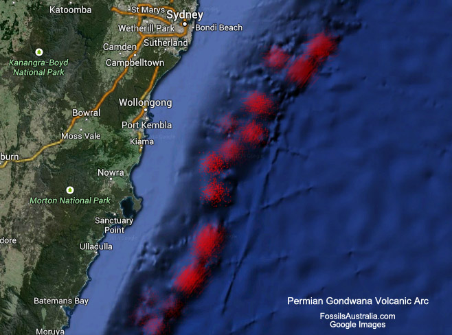
Top: In red – Permian Gondwana Volcanic Arc.

Top: Kiama NSW – Bombo basalt latite over sandstone
Permian 275-248 million years ago.
Eventually temperatures increased and the sea became swampy delta forests that layed down over 38 million years vegetation faster then it could decompose, this ‘peat’ compacted down to become the coal seams
(Illawarra coal measures) that fuels much of the historical coal industry of the area.
The trees of this period, mostly Glossopteris, a primitive gymnosperm (gymnosperm include conifers and have unprotected seeds) were not like the eucalyptus we see today but were seasonal and dropped their leaves in autumn, this has led to the assumption that Golossoptris may have contributed greatly to coal formations as in some locations the majority of coal is made up of Glossoptris leaves and the direct plant debris.

Top: Large Glossopteris tree trunk – Allans Creek Formation Sydney Bain
Observations indicate that peat is compacted by a factor of 10 in the formation of black coal. This means that a workable 1 meter seam of coal would require an original peat thickness of 10m. The accumulation of peat is a slow process in cold climates with 1mm per year being deposited, this means that it takes 1000 years to lay
down 1m of peat. If we use the ratio of compaction (1:10) then 1m of coal could have taken 10,000 years to accumulate.


Left: Tongarra Coal Measures can be seen at north Austinmer beach
Right: Close up of the Tongarra Coal measures (30cm ruler for scale).
The gray layers are ‘tuffaceous’ airborne volcanic ash deposits.
According to Geoscience Australia the maximum thickest of the Illawarra Coal measure is 150m, such coal would have required some 1500m of peat and as you can work out would have taken 1,500,000 years to accumulate.
In 1897 a shaft was sunk in Birchgrove Sydney to reach economic coal, the seam was 864 m underground and took over 5 years to sink. This is an interesting insight into subsidence as the last visible outcrops of coal can be found around Coal Cliff, south of Sydney, with the seam being at sea level, this would indicate that north of Coal Cliff the direct Sydney basin has subsided considerably beginning in the Triassic.
If you get the chance to check out the Bulli Coal Measures that is visible under the Sea Cliff Bridge you will note the cut-off at the top of the coal layer, it is at this period 80% of species on earth became extinct and was believed to have been caused by volcanic activity in Russia (‘Siberian traps’) + volcanic activity in China that lead to a global runaway green house effect. At this time around Gerringong evidence of late Permian volcanic latite (lava) flows can also be found along with ash fall tuffs (gray ash layers) that are visible in the late coal measures indicating regional volcanic activity until the end of the period.
The layer directly above the Bulli Coal Measures marks the end of the Permian & beginning of the Triassic or the Permian–Triassic extinction event.
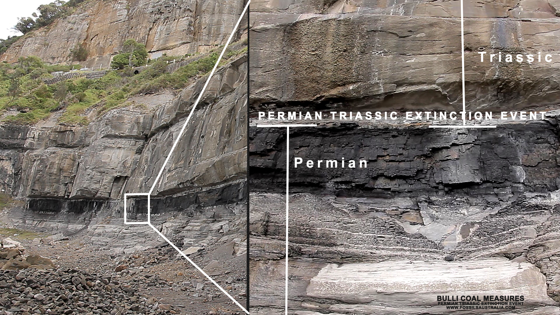
Top: Bulli Coal Measures and the Permian Triassic Ectinction Event Boundary
Triassic 248-213 million years ago.
Above this coal layer we find the Nepean and Hawkesbury sandstone made from a mixture of shale’s, sandstones, claystone and conglomerates sedimentation deposit, formed from where a fast flowing streams flatten, slow, and spreads typically onto a flatter plain called an ‘alluvial fan’.
Alluvial fans form around the edges of mountain ranges and are made up of sand and gravel that is shed from a rapidly eroding landscape.
Looking up at the escarpment of the Southern Highlands or the sandstone cliffs of Sydney & the Blue Mountains it is difficult to imagine where all of this sediment came from? The answer to this is varied and is still a debated topic, some suggest it originated in Antartica (which was still joined to Australia) others suggest it came from as far away as Broken Hill which is probably the least likely due to the Great Deviding Range which formed during the Carboniferous period some 300 million years ago that would have acted as a barrier to the sediment supply. A simpler explanation may be that due to the rise in temperature and the melting of ice that would have covered much of the area surrounding the basin (and at times the basin itself) sediment was washed down towards the low lying peatland basin like the ones found at the end of the Permian towards the coast, as it does the sediment fans grow, this sediment intrudes onto the peat land overlaying the peat eventually covering much of the lowlying basin extending offshore in the formation of a delta. Various cross-bedding within the sandstone suggest variation in flow direction, velocity and water depth during deposition (depositing of the sandstone).

Why then does the sandstone stretch from Newcastle in the north to Batemans Bay in the south, and west to the Blue Mountains towards Lithgow, and up until the edges of Mudgee in midwestern New South Wales? The answer to this is that it is typical for these fans to grow outward for a while, and then for the flow to switch to the side, forming another fan. Over time as the fan switched, in conjunction with river floodplains channels that can at any one time be 500-1000m wide, sedimentation was eventually deposited over the large region of the lowlying Sydney Basin. Old river channels are exposed in the freeway cuttings in various location around Sydney, The Three Sisters of the Blue Mountains, the escarpment etc. A modern example of this kind of process is the Brahmaputra river that drains the southern side of the Himalaya, these modern river deposits can be 100-200km across.
An interesting thing to keep in mind is that 240 million years ago there was no ice at the poles, warming was occurring at a time when the South Pole lay near Bourke in northern NSW. The climate had increased and the rivers, creeks, that transported vast amounts of sand & sediments offered habitats for all kinds of flora and fauna of the time, at various locations ‘small’ deposits of coal can be found that indicate extended periods of plant deposits, a good example of this is Erith Coal Mine in Bundanoon. This along with other small coal seams and shale’s tells us that the whole area was not just a big sand pit, but constantly changing with life at the time trying to keep up.
The beginning of the Triassic was a chaotic period for life on earth with it’s impoverished biosphere, high CO2 levels and increased temperature, it would take well into the middle of the period for life to recover to its former diversity. As temperature & CO2 fluctuations settled down a specialized subgroup of archosaurs (group of diapsid amniotes whose living representatives consist of modern birds and crocodilians) aka dinosaurs, first appeared in the mid-Triassic with a specialised ankle joint that enabled them to walk upright. First true mammals also evolved in this period.
Jurassic 213-144 million years ago.
Around 200 million years ago in the Jurassic isolated volcanoes exploded up through the shale, coal & sandstone. Remains of around 95 volcanoes can be found in the area one of which is Mt Gibraltar, Bowral that pushed up 150 million years ago. Griffith Taylor and Douglas Mawson who mapped this area in 1903 thought the The Gib was the exposed core of a volcano. The appearance of microsyenite indicates that this intrusion took along time to cool which may indicate that it was connected to a heat source for some time. This rock was used as a building stone in Sydney, many city streets have kerbs of mircrosyenite which has resisted weathering for years.
Cretaceous 144 -65 million years ago.
Although sandstone fossils for this area are rare the ones that are discovered offer an insight into what it may have been like during this period. A few years ago a fossil collector found bone fragments amongst rocks that had been bulldozed for road works near Picton, after six years a near-complete one meter long fossil of a fresh water shark Xenacanth was reveled. Another example is of an large salamander amphibian that was discovered in a lump of sandstone that was to be used as a garden terrace in 1997.
It was during this time that the Australian continent finally separated from Antarctica at around 85 million years followed by the world wide extinction of dinosaurs 65 million years ago.
Cenozoic 65million years ago – Present Day
As Australia drifted north, a ‘hotspot’ underlying the mantle pushed up through the continental plate to form volcanoes and lava fields that extended down eastern Australia, parallelled offshore by two lines of volcanic seamounts (A seamount is a mountain rising from the ocean seafloor that does not reach to the water’s surface). As the continent drifted north the hotspot remained stationary pushing up though the crust every few million years. This volcanic chain extends from the north of Queensland to Tasmania, the volcanoes become younger as we move southward. The hotspot is currently off the north coast of Tasmania at what is know as the ‘East Australian Hotspot’ with it’s sister parallel at the ‘Tasmantid Hotspot’.

Volcanoes extended from the north some 32 Million years ago to the south (0Ma).Volcanoes become younger as we move southward.
Red: Volcanoes
Orange: Lava Fields, erupted from fractures and spread over areas 100Km across.
Green: Current Hotspot Location
Lava flows believed to be around as thick as 60m covered most of the Southern Highlands, the result of passing over this hotspot some 35-8 Million years ago. The source of these flows is uncertain, but may have been from vents just east of The Gib, (not the Gib itself) Saddleback Mountain, Robertson, Moss Vale and the Camden area. The basalt from the flows that covers much of the highlands came from molten rock that was originally 2000 km underground.
The oxidized iron in the Black Basalt weathers down to red soil, most noticeably seen in Robertson.

Crude example of hotspot some 35-8 Million years ago.
As Australia drifted north, a ‘hotspot’ underlying the mantle pushed up through the continental plate to form volcanoes and lava fields that extended down eastern Australia.
The above image shows the hotspot and lavafields of Camden and the Southern Highlands, a few million years may have passed between each lava field.
The eastern edge of the Southern Highlands plateau uplifted along with the Blue Mountains around 70-35 million years ago. The uplift occurred around the same time that the area passed over the ‘Eastern Australia Hotspot’ and it may be due to the passing over of the hotspot that the Southern end of the basin was uplifted, since eroded to its present height around 30 million years ago. Small fault fractures caused by the uplift may have enabled the viscous low silica lava to push through creating the various lava fields of the area around the same time. The escarpment plateau is not a fault as many believe and would have extended to the edge of the continental shelf being eroded by various factors including denudation, rivers that flowed east causing erosion (forming lowlands like the Illawarra) and direct coastal erosion (like that at Stanwell Park) and possible subsidence caused by loading.

Robertson Lava Fields.
Red: Lava Fields
Gray: Location of small localised uplift and possible gas escape structure.
If you want to check out what occurred to the sandstone as the lava was push up to create the lava fields, enter the Sydney Waterboard at the bottom of the hill on Kangaloon Rd and follow the track to the north, it is at this point that you will see a large a sandstone mound to the right that was uplifted as a possible gas escape fracture to the adjacent lava fields. This gas escape structure may have been the result of lava heating the underlying water table of the pre Nepean River. You can follow this structure for some distance to the west and it gives a great example of the power and destruction that this region would have encountered at the time. (Please note that unfortunatly there is a fine if caught in the Sydney Catchment, enter at own risk)
As Antarctica and Australia separated circumpolar currents began to cool, 30 million years ago the air and water temperatures cooled rapidly, by 15 million years ago much of Antarctica was glacial. Australia at this time began to dry out and there was an increase in plants typical of drier forests and woodlands, sea levels dropped to 100m below the present levels.
East-west rainfall gradient and differences in soil / erosion controlled the vegetation that ranged from rainforest’s, woodlands, heaths to dryer sclerophyll forest.
The post-glacial rise in sea level between 18,000 and 6,000 years ago drowned the coastal plains and river valleys that extended to around 15km off the coast. Fronted by confined barrier systems of beaches, dunes and coastal lakes the coastal area accumulated organic matter and begin to develop coloured subsoils that can be seen today.

Rock falls and denudation Thirroul
The Future
The local area is still evolving, the escarpment is being eroded with regular rock falls and denudation (processes that cause the wearing away of the earth’s surface leading to a reduction in elevation) at about 2-5 meters per million years. Subsidence in the area occurs frequently with minor tremors being felf every 30 years or so. A magnitude 5.6 earthquake hit Robertson, Bowral, Moss Vales on the 21st of may 1961 and caused 4.1 million dollars in damage.
Tsunami are predicted to hit the eastern Australian coastline every 100 years or so due to the boundary of the Pacific Ocean, known as the Ring of Fire that experiences frequent earthquakes. Since the Pacific Tsunami Warning Centre was set up after 2004, 52 tsunami alerts have been issued that may indicate that it may be a more regular then previously thought.
That aside it is important to remember that things are changing, earth and the local geology is constantly evolving, being shaped by the various geological processes.
What will be the future of this area? As we head slowly north at a rate of 7cm a year we will eventually run into India, during our few hundred million year trip north the magnetic poles will flip from north to south numerous times, temperatures will increase which will mean at some point in the distant future this area will once again become tropical forests.
The escarpment will slowly erode to become a gentle slop down to the lower coastal edge, the seas will be higher and depending on how long temperatures continue to rise there will be drastic sea level rises, The IPCC (Intergovernmental Panel on Climate Change) Third Assessment Report (TAR) projected a sea level rise of 20 to 70 cm by 2100.
It is important to keep in mind that we are currently coming out of an ice age and we still would have done so even if human did not exist. Our ice age may be ending but it will eventually come back, predicable not in the foreseeable future but at some point again earth will return to current temperatures, cool and then freeze, warm and cool again, this is as the geological record tells us the story of our planet. So enjoy the warm while it lasts and remember to pack your swimmers.
